
Spring is finally here and music festival season is beginning. Two of the biggest music festivals are happening this month – Coachella and Stagecoach. In 2017, Coachella had over 250,000 attendees, and Stagecoach had its highest attendance of 75,000 people in 2018.
Music festival venues are large spaces with different areas and attractions for attendees to enjoy. But moving around these spaces can be difficult with so many other people, and it can be tough to know what to do and when. Mobile-friendly interactive maps can be a powerful way for festivals to showcase the grounds and hype the excitement before a show, and help festival-goers as well as staff, vendors and sponsors find their way around.
It’s shocking that the static PDF map remains prevalent for many venues because static maps not only require manual updating, but they also leave many, many opportunities untapped for unique sponsorships, connectivity, wayfinding, and immersive experiences before, during and after an event.
Rather than accessing a static (and often difficult to understand and manipulate) graphic on a phone, music festival organizers and venues can offer a fully interactive map to every visitor. This makes it much more fun to explore, and by dropping in images and 360-degree pans, visitors can see exactly what the grounds will look like. These immersive images can help attendees select their campsite, learn their way around the venue before showtime, and locate restrooms, concessions, and other attractions. What were Fyre Festival attendees asking for over and over again before the unfortunate happened? Images!
Here are several ways that an interactive map can change the game for festival organizers and venues.
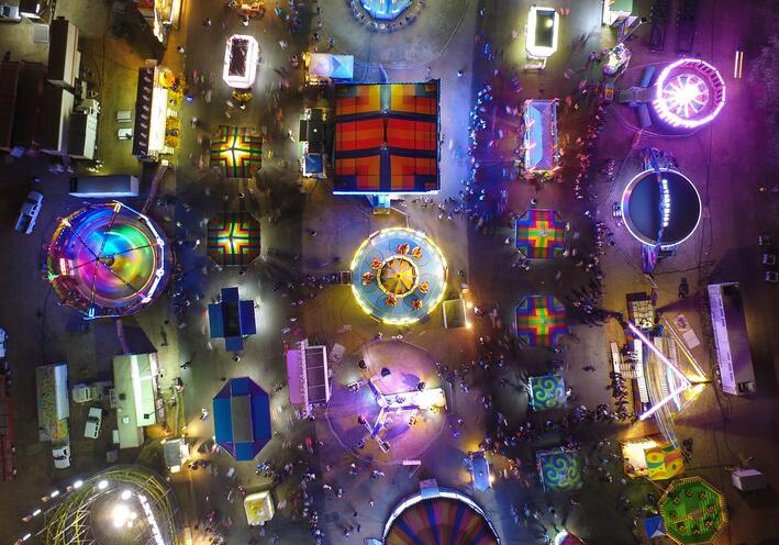
The Bird’s Eye – Viewing the Entire Venue
Music festival event venues are often extremely large. For example, Coachella is hosted at the 78-acre Empire Polo Club, but when accounting for land used for parking and camping, the event covers over 600 acres of land. Navigating all of this ground can be quite a feat and an interactive map is a perfect way for users to be able to jump back and get the bird’s eye view, then dive into more detailed areas. PDF maps simply can’t do that.
An interactive map can show all of the different areas in one place for viewing – stages, parking lots, campgrounds, you name it. Point-to-point walking directions can be integrated and the map can give attendees a very clear idea of where they actually are and how far away they are from any part of the festival.
Parking Assistance
Parking at large events such as a music festival can be a nightmare. However, with the assistance of an interactive map, different types of parking can be highlighted for user ease. Additionally, venues can go a step further and use digital maps to track open parking spaces across the venue. By using connected sensor systems, parking availability within a lot can be tracked and then visualized on a map. Even simpler, color coded lots can be shown on the interactive map and map users can get driving directions directly.
Transportation
Aside from parking, interactive maps can integrate real-time transportation tracking info. This data can show the estimated time of arrival of the next shuttle, where stops are, and other information. Designated ride sharing pick up and drop off locations can also be clearly labeled on the map.
Concessions, Restrooms, & Other Attractions
When you inevitably have to use the bathroom at a large event, actually finding the nearest bathroom can be a challenge. However, interactive maps can simplify the process.
Bathrooms, places to eat and other additional attractions can be labeled on an interactive map, helping users find the closest facility to them. Additionally, walking directions can assist users to getting in getting to and from different areas of the venue. From a sponsorship standpoint, vendors could pay more to be featured on the interactive map, including special offers during happy hours, brand activations, and other experiences. Festival goers can sign up for these right from the interactive map, and receive a push notification on their mobile device letting them know when it’s about to start.
Marketing Assets
Music festivals such as Coachella and Stagecoach are expensive. On top of ticket prices, many people have to fly to attend these events and have additional costs outside of the festival itself. According to Money.com, the average cost to attend Coachella is more than $2,000.
Because of the cost of these events, organizers and venues are doing whatever they can to show just how amazing the event will be. By bringing the grounds to life with 3D renderings, all built into an interactive map, people will spend more time exploring and getting excited, making them more likely to invest in the experience.
Having immersive media such as VR-enabled tours (easily accessible via the interactive map) built into a website is a powerful marketing tool. 360° tours can take visitors right into the action from a previous event, next to the stage, behind the stage, or into a campsite. Virtual reality is a perfect marketing tool to show potential attendees what it is actually like to be at the event and can help justify the cost associated with attendance.
There is so much potential for interactive maps to enhance the festival goer experience, and as connectivity continues to grow, there will only be more and more options.