If you operate a large venue, you know how difficult and frustrating it can be for your visitors to try and find their way around. Thankfully technology has advanced quite a bit from the simple folding maps or “you are here” installations that we used in the past. These maps have a number of advantages over older methods. In this blog post, we will take a look what 3D rendered maps are as well as how they can help your customers.
What is 3D Rendering?
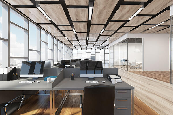
In order to understand the advantages of what 3D rendered maps can do, we must first understand what 3D maps are. A 3D map allows Concept3D to exactly model the space we are mapping. This means that the rooms of your building will be to scale. It will be such an accurate model, that you could use it to rearrange your venue’s furnishings. Having a fully realized and to scale 3D model to look at will aid your visitors in getting their bearings as they navigate around your venue. It also allows for significantly more advanced wayfinding than would be allowed for with less exacting technologies.
Now that you have some idea of what 3D rendering is in relation to indoor mapping, let’s take a look at some of the ways that it can be used to improve the experience of your visitors.
Modernized Blueprints
Architects have used 3D renders (called ArchViz, or architectural visualization) for years to show potential clients what their buildings will look like before it is even built. We can use the exact same technology to bring your venue to the customer before they bring themselves to you. This will allow your future visitors to gather their bearings and understand a little about the layout of your venue before they even leave their sofa. This way, when they do arrive on your property, they will be a little more confident about finding their way around than they might otherwise have.
Wayfinding
More than likely, your visitors are going to be very familiar with using tools such as Google Maps for finding their way on the roadways. Having a precisely mapped 3D model of your venue allows us to create a similar system for the indoor navigation of your building or buildings. This brings a powerful new navigation tool to your visitors that a simple drawing cannot provide.
The indoor wayfinding can be customized to help your visitors follow a task. This could be something like guiding a visitor of a museum through a tour or guiding a patient at a hospital to the various locations they need to travel to and from for a given procedure. Perhaps your visitor is disabled and needs special directions that include ramps or elevators. Having all of the information contained digitally makes creating such custom routes easy.
Best of all, because these maps can be viewed on any digital device, you no longer have to worry about your visitors accidentally leaving their map behind or struggling to find the next “you are here” map. Just like the street directions they use on Google, they’ll have their navigation aid of your facility with them at all times.
Data Overlays
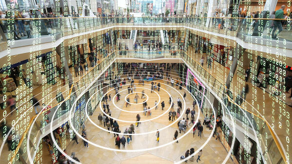
Sometimes, simple indoor navigation is not enough. Imagine you have a visitor that is navigating your venue to find a location where they can pick up a wheelchair or some other needed item. If your venue has multiple locations for these, and one of them doesn’t have any wheelchairs available, then your visitor could waste their time navigating to that site. Digital overlays allow you to show your visitors in real time how many items are available at each location with data feeds.
Of course, we needn’t limit this to any one thing. Any item that may be rented or loaned out to visitors or staff can be tracked, and data related to that item updated in real-time. The digital indoor mapping made possible by 3D renderings allows for that information to be displayed to the end-user before they even start their journey. This allows them, or the waypoint calculations themselves, to find the best possible route to get what they need quickly with no backtracking and no disappointments.
Incorporated Video
The digital nature of 3D renderings allows you to incorporate video into your maps. This can provide many advantages to someone using the map. It is easy to imagine a museum using a video to give a detailed explanation of an exhibit without requiring the visitor to stick to the schedule of an organized tour. Other, more creative uses of video can also be achieved with a 3D rendered map. Imagine a venue that has machines or some other process that requires instruction. Perhaps you currently have a chart on display somewhere that instructs people on what they need to know about a given location. The instructions can be given in much more detail if they are presented in the form of a video incorporated into the map that the visitor or staff member is already using.
Because the digital device that they use to access the video is always on their person, this makes providing information more convenient to the user than on-site charts or audio recordings can be. They can access this video from any area of the location and do not have to worry about a large group of people all crowded around trying to get to the information. Although incorporating video is not directly related to navigation, reducing crowding in this way will certainly help with the flow in your venue.
Conclusion
Every venue is different. Every business has different needs. Any relatively large area with public access can benefit from indoor navigation with 3d rendering. Some businesses may benefit from it even if only staff will access it. When designing your mapping solution, consider the ways that it could be enhanced by some of the technologies we’ve discussed.