What Are Map Styles?
Concept3D’s interactive map is known for its options and customizations. Under that umbrella is map styles.
Map styles are options across the map rendering when initially created. There are branding options like coloring, logos, favicon, text options, and certain design options are available through the content management system while map styles are rendering options as part of the 3D renderings.
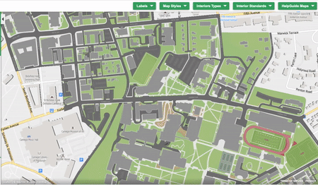
Experience it for yourself with our Map Styles map. The power of this map is the dropdown buttons across the top.
As the options within the button dropdown are clicked the map will automatically change to represent that style. Dropdown Interior Types and the six options will appear, click Basic 3D, and the interiors within the map will show Basic 3D interiors.
Map Labels
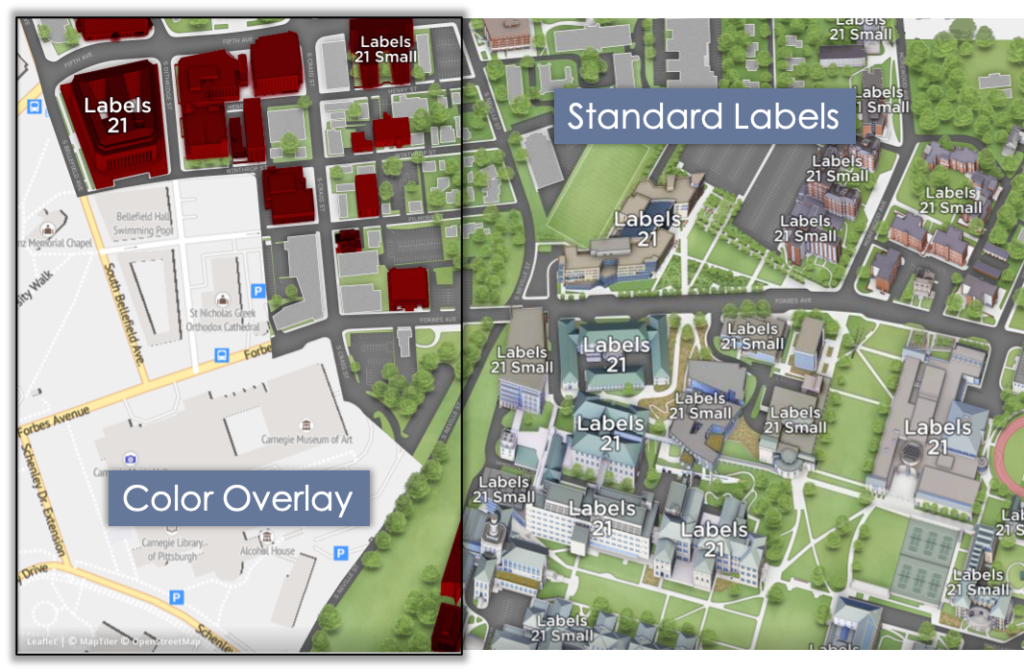
Map labels are how key locations like buildings, large areas, and roads are labeled. There are two options, Color Overlay and Standard Labels. Color Overlay conforms to the shape of the building with a written label over the shape. This option is great for readability and for color-blind users if certain colors are used. Standard Labels are written labels over the building, area, or road.
Map Styles
Where the general term map styles come from, map styles are the options available for the exterior renderings.
Concept3D has a standard exterior rendering style. This is our original secret sauce that we have continually improved and optimized over a decade. However, there ways to highlight or use the rendering to tell the location’s story.
- Monopoly Style – Still 3D but no details like colors, textures, or windows are shown
- Ghosted Area – The rendering is visible but it is greyed out
- Muted Green Area – Same concept as Ghosted Area but green rather than grey
- 2D with Trees – Buildings are greyed outlines of the building’s footprint however natural areas are rendered in 3D
- Flat 2D – Building are outlined as in 2D with Trees but natural areas are a single color, no 3D elements
Interior Types
Interior renderings are used for many reasons from accessibility compliance to marketing. Interiors are sometimes used to highlight and make findable on the map all accessibility resources, like elevators and handicapped restrooms. Or interiors are used to show the differences between room types and the resources in that room; AV, capacity, seating options, and so on. These are the options:
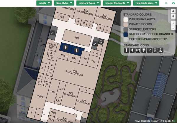
- 2D Interiors – Has 5 colors to callout public areas, private, bathrooms, stairs and has simple labeling and standard icons for things like bathrooms and stairs, no 3D
- 2D + Furniture – Like 2D Interiors but the furniture and set-up is shown, no 3D
- Basic 3D – Same color and icon options as 2D Interiors, but the walls are extruded to create 3D interiors
- Basic 3D + Furniture – Same as Basic 3D with furniture
- Detailed 3D – Extrude walls with rendered stairs, windows, and doors
- Detailed 3D + Furniture – Detailed 3D with 3D furniture
Standards and Help Guides
The last two dropdown buttons on the Map Style map are Interior Standards and Help Guide Maps. Interior Standards outlines the specifics of interiors, the angle of the labels, and what will and will not be labeled. Help Guide Maps take the user to other interactive map guides like the Map Styles map.
This blog is the first of four user guides for Concept3D’s interactive map guides. In addition, to Map Styles, there are interactive map guides for Concept3D features, our clients, and the render process. Keep an eye out for the rest!