
Thanks to the advent of 3D mapping software, virtual maps are quickly redefining the purpose and value of a map. To most people, a map is still just a tool of utility that gets you from point A to point B, nothing more.
But in the new virtual world, maps connect people with ideas, immerse them in stories of history (and glimpses of the future), and train and educate them in ways society has never imagined, except maybe in sci-fi films.
The Story of a Place: How 3D Maps Are Uncovering the Past
In an article titled Archaeologists Dig Into Data, Not Dirt, a group of archaeologists from the Foundation for Maya Cultural and Natural Heritage stumbled on something astounding: a 1,500-year-old Mayan settlement complete with cities, agriculture, and networks of transportation–all previously unknown.
How did they do it?
They didn’t have to lift a single spade or scoop any dirt. They used an aerial laser-scanning technology to pierce a thick tree canopy and create a 3D archaeological map of an 800 square-mile region. Using their 3D mapping insights, they discovered a world that would have made Indiana Jones gasp with wonder: previously undiscovered structures that included houses, canals for irrigation, agricultural regions, defense measures and pyramids. Their efforts revealed the newly discovered Mayan settlement had once been a bustling civilization of about 10 million people.
And the researchers didn’t have to disturb the environment or move a single pile of dirt to learn this. They simply had to go exploring using a virtual map.
This is exactly how 3D mapping software is changing the world: people are now using maps to explore, embark on virtual adventures, connect with people of the present and the past, and enrich their understanding of the world and history. Thanks to virtual maps, you can now take a virtual tour of the Louvre, the US Supreme Court, or stop by the Taj Mahal, just to name a few of the amazing places now available to you with a single click. Virtual mapping allows programmers to place useful blurbs of facts about important spots in each location on the virtual tour. As virtual tourists explore the 3D environment, they’re not only seeing the stunning visuals, they’re learning about the location and its history.
Maps are becoming compelling voices of narrative, in other words. Maps have always had that tendency. As Smart History astutely observes:
Maps are narratives that tell a story of the time and people of their origin, even the modern Google Earth is a product of subjective choices of visual signs and symbols of our time. These seemingly objective maps, like any other, involve selections of information, human editing, and a visual language legible to the current end user.
3D maps are amplifying that narrative power and helping the modern world tell its own story in powerful, unprecedented ways.
3D Maps Connecting People With Ideas and Data
Maps are also becoming hubs of information: ideas and data that assist, enrich and expand a person’s understanding and give businesses, organizations and governments new ways to accomplish their objectives.
3D renderings within maps are making this possible especially through the use of its stunning visual capabilities.
The Power (and Sheer Joy) of Visualizing Data
Data mapping software, interactive maps and virtual visualization are combining with the Internet of Things (IoT) to create a visualization of data.
How does this work exactly?
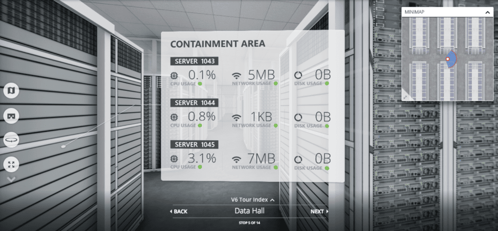
IoT involves placing sensors on physical objects in the environment being mapped. Virtual mapping technology combines 3D models, real-time video and sensor data to produce immersive environments that astonish its users. Companies, schools and organizations are using these interactive virtual tours to exceed the expectations.
It’s not just about tourism and personal enrichment. Businesses are making wide use of the visualization benefits of 3D mapping software. The maps allow them to optimize inventory logistics and utilize space more efficiently in warehousing. Interactive virtual maps, when connected with IoT sensors in physical space, pull in data from all over the place–phones, cars, factories, vehicles–compiles all of it and presents it in a way for you to easily interpret.
It’s creating highly organized real-time information that is shareable in a visual medium. You’ll see how layers of information on maps are interacting, and you’ll be able to make smarter decisions.
Job Training
If you’ve seen any of the Avenger movies that feature Iron Man, you’ve likely seen Tony Stark using 3D visualized models to analyze and solve problems. Virtual mapping is beginning to take job training to a Tony Stark level. Whether you’re teaching someone how to handle disaster response or giving your new employees a virtual tour of facilities, the interactive virtual mapping allows you to immerse them in the environment in ways never before possible.
Education
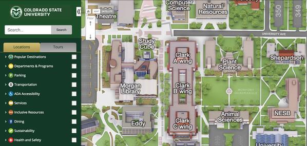
3D mapping software has also been revolutionizing how universities present their campus map to current and prospective students. For example, Concept3D has created a content management system (CMS) that gives admissions, marketing, facilities, and others the ability to design media-rich interactive campus tours that holds the interest of prospects and assists and educates students, parents, staff and alumni in powerful ways.
(As an example, you can visit Concept3D’s Duke campus map, which has been used by the famous college as a tool for recruiting and an operational platform for over ten years.)
Virtual mapping technology has already been developed to include Section 508-compliant modifications including text-only versions, ARIA tagging, style and alt-tagging options, and the highlighting of ADA-compliant restrooms, routes, entrances, and parking spaces.
How Will You Use Virtual Maps to Connect With the World?
Frankly, the amazing developments above only scratch the surface of what’s possible with virtual maps and 3D mapping software. At Concept3D, we’ve had the exciting and rewarding opportunities to create virtual maps in every category mentioned in this article, and each project has shown us the incredible potential of this technology.
And it’s only getting started.
The real question is, how will you use this stunning technology to connect with the world? Or maybe even a better question: how will you use it to change the world?
The sky’s the limit with virtual mapping. (And you can probably map the sky too if you really wanted to.)