
A recent article in the Chronicle of Higher Education uncovered a stark truth that many administrators across the United States already suspected: the industry is in crisis. According to its survey, six in ten universities missed their enrollment goals last year. In that same time period, more than half missed making their budget projection.
That data suggests an urgent need to act and improve. Student success, if it hasn’t already, needs to become a major enrollment factor in connecting directly with retention rates. Meanwhile, more efficient operations across campus are vital to not just prevent and operate functionally during emergencies but handle major events successfully and without negative budget implications.
Far be it from this article to suggest that live transit feeds, integrated into digital campus maps, are the solve-all for these major hurdles across higher education. It is realistic to suggest, however, that they can play a central role in helping to overcome those hurdles.
In more ways than one, digital campus maps have begun to revolutionize the ways we think about location-based university marketing. Virtual tours transform the way universities recruit remote students. Real-time data integration has made these maps more high-tech and usable than ever before. This is the environment in which transit feeds can make a major difference.
The Basics of Transit Feeds in Campus Maps
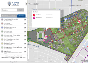
Digital maps have become a core piece of the online experience for many universities. Institutions of all sizes use them to allow for easy navigation for all audiences. Many even add bonus features like virtual tours to enhance the experience. Done right, the modern campus map becomes a vital marketing and wayfinding tool.
At the same time, we’re just beginning to uncover the potential of campus maps. Transit feeds are a perfect example of that potential.
Through live data feeds, audiences are able to see and plan for campus shuttles, bus and subway stops, and more. That, in turn, leads to significant benefits for both the university and its audiences in a variety of ways.
This article will dig into these opportunities, but it’s important to start with some context. Live data feeds, particularly when they relate to public transit, require careful consideration and build-out. Without the right graphic interface, the user experience will suffer as the map becomes more confusing. This is, without a doubt, a significant opportunity — but one that has to be considered carefully.
5 Ways in Which Transit Feeds Can Benefit and Transform Universities
Let’s dig into the details. Executed the right way, any transit feed can benefit your university. But when they’re a part of a larger plan, that benefit becomes more significant.
It might sound exaggerated, but a transit feed — especially when integrated into larger efforts surrounding emergency communications, wayfinding, and student success — has the potential to transform your university. That’s why we’ll consider each of the below points both in isolation. We’ll also discuss the potential role they could play for larger, university-wide, and institutionalized communications efforts.
1. Optimize Transportation Across Campus
The first and most obvious benefit for transit feed: they can optimize the way students and every member of the university gets across campus. Universities are beginning to discourage cars on campus for a variety of reasons:
- Cars make the campus less safe, as indicated by a study performed by Johns Hopkins University.
- They can conflict with university-wide initiatives to become more sustainable and reduce emissions.
- Cars can crowd the campus and reduce the community feeling that so many universities prioritize.
Partially as a result of these efforts, the percentage of students on campus who own a car has dropped below 50%. Especially at larger universities, that means they rely on public and campus transit to get around.
Live feeds of buses and public transportation allow these students to plan their days and get where they need to go. They can quickly check on their laptop or phone when a bus will arrive, and reduce the amount of wasted or waiting time in the process.
This optimized transportation, in turn, can have a significant impact on student success. Students who know how to get around will miss less class time, and become more likely to make appointments with professors and advisors. They also tend to be more easily available for out-of-class experiences.
Research repeatedly shows academic availability and engagement in student life activities to be major student retention and success drivers. Optimizing transportation through live data feeds, and communicating that opportunity to students on a consistent basis, can play a core role building towards that success.
2. Manage Traffic Flows For Major Campus Events

It’s no surprise that every university regularly manages major campus events. It’s also no surprise that they quickly turn into a logistical nightmare. Some examples include:
- Move-in weekend, when thousands of families help their first-year and continuing students turn empty dormitories into livable spaces.
- Homecoming, when thousands of alumni come back to campus to meet up and reminisce about the good times alongside current students.
- Major admissions events such as open houses, designed for potential students and their families to see the best of the university.
- Commencement, when friends and families return to campus in order to celebrate the (often large) graduating class.
- Sporting events throughout the year, especially when the stadium is integrated into campus to increase school spirit.
Digital maps can solve many of these challenges through more effective traffic routes and parking information. But don’t underestimate the potential power of transit feeds. Especially if you employ parking shuttles at satellite or edge-of-campus locations, being able to show the arrival and timing of these shuttles helps to better manage the traffic flow at every event imaginable.
This type of traffic management reduces immediate logistical challenges, but don’t underestimate its long-term impact. A less-crowded campus makes it easier for current students to join the events, as they don’t have to fight through traffic or look for parking in vain. That, in turn, increases school spirit – once again leading to increased chances of student success.
3. Real-Time Updates to Campus Maps During Emergencies and Inclement Weather
Both of the above can be achieved, although incrementally less, through static bus and shuttle times available online or even as part of the digital map. That’s less convenient and doesn’t drive home the same degree of benefit, but goes in the same direction. The same cannot be said for situations where the typical schedule gets disrupted.
Like most campuses, chances are your university has an emergency plan in place. It likely covers anything from slight inclement weather to potentially life-threatening situations. Does that emergency plan include the way buses and shuttles operate?
It might seem obvious, but students don’t tend to think about services being disrupted. More importantly, they rely on them to get back to where they need to go when their regular life is disrupted. Heavy snow may cancel class, prompting students to get back to their own room. A more serious situation at the edge of campus may prompt a natural reaction of taking a bus to get away from it.
However, buses may not operate as they usually do. Live traffic feeds allow for that change and potential delay quickly and effectively. That prevents bottlenecks and results in a more efficient flow of students across campus.
To have that effect, of course, traffic feeds can’t just exist; they have to be integrated into a larger communication plan.
4. Improved Community Connections and Town-Gown Relations
Especially for urban universities, strained relationships with the community in which they live are a constant concern. As a 2019 article by the Chronicle of Higher Education put it,
Despite progress on other fronts, questions of sustaining true community partnership built upon equity, inclusion, and even, in some cases, reparations remain pressing at most institutions and within most communities. It takes more than rhetorical commitments, no matter how well-intended or passionately made.
A community integrated with its university offers a more lively student life, alternative residency options, and plenty of sites for internships and post-graduation jobs. The efforts range far beyond transit feeds, but these transit feeds can become a core part of the infrastructure.
Close partnerships with local transit authorities could allow live transit feeds to extend beyond shuttle buses to public transit, including bus and subway traffic. That, in turn, results in more opportunities for students to get off-campus. That community music festival or internship at the local hospital suddenly becomes more achievable even for students without a car.
Don’t underestimate the reverse potential of this type of arrangement. Community members with access to a digital map that extends beyond campus borders can use it as a valuable tool to get around. They can even attend campus events more easily to bring them in and improve their connection with the university community.
Live transit data doesn’t solve town-gown relations. But it can provide the baseline for more interactions between both sides of the issue, bringing each community one step closer to each other in the process.
5. Introducing the Potential of Real-Time Fleet Management
The technology behind traffic feeds and GPS tracking in itself has major benefits for universities able to leverage it. That GPS typically feeds into some type of mapping solution that may be separate from the public tool that’s become common at most universities.
As a recent article in Ed Tech Magazine explained, this technology provides opportunities that are worth exploring for any university who can implement it:
- Better rider experience through more on-time transportation, saving in responding to student complaints, and increasing overall satisfaction.
- Reduced insurance risk and costs due to a reduced risk in theft or loss. Universities can potentially save thousands in insurance premiums as a result.
- Better driver tracking, which results in increased visibility for fleet management. It allows fleet managers to track vehicle usage, driver utilization, and more purpose-driven vehicle planning.
- Tracking safety events, such as harsh braking or rapid acceleration. That can lead to implementing better and safer practices for both drivers and riders alike.
The traffic feed, in this case, is not just beneficial for the public. It’s a great internal tool to help fleet managers and administrators improve the way vehicles across campus are being used. That requires a different type of implementation, but can still result in significant ROI and safety advantages.
The implementation may be a layer on the existing campus maps that are available only to relevant stakeholders, or a duplicate of the public map that accomplishes the same goal. Its internal uses mean it will not see the light of day, because vehicles tracked go far beyond campus shuttles. Still, the benefits of this type of internal capability are impossible to overstate.
Are You Ready to Transform Your Campus Maps Through Live Transit Feeds?
Digital maps are just getting started. Live transit feeds are a perfect example of how real-time data integrations could transform and are already transforming the ways we consider maps today. For both internal and external audiences, these traffic feed maps result in better communications, more optimized transportation, and significant cost and satisfaction advantages.
The time to invest is now. Institutions like the University of Alabama and Penn State University are already integrating live feeds into their campus maps, and seeing positive results in student satisfaction as well as traffic management as a result. Considering long implementation windows, it’s vital to begin early planning now to be ready when the still-new technology begins to become mainstream.
Of course, you have to take the time required to get it right. A quality implementation is more important than a fast implementation. That means working with a reliable partner who has both the experience needed and industry-specific knowledge to guide you through both planning and implementation.
Concept3D has extensive experience in the digital map space, including the ability to integrate live GPS tracking and other data opportunities.